Here at 360 Virtual View we produce (almost) everything you could need to help you promote your holiday let, holiday property or AirBnB. But did you also know we produce CAD models, Home Reports and GLA documents? Here are some examples of the assets and images we produce. For examples of other services such as Matterport Virtual Tours or Drone photography, see the other pages on our site.
On this page:
- 3D floor plans
- 2D schematic floor plans (estate agency style)
- Digitally rendered virtual video walkthrough
- CAD models for residential properties
- Interactive photographic 3D models
- GLA documents
- Home report
- Snapshot report
For more information on any of the services, get in touch with us on 0114 383 0711
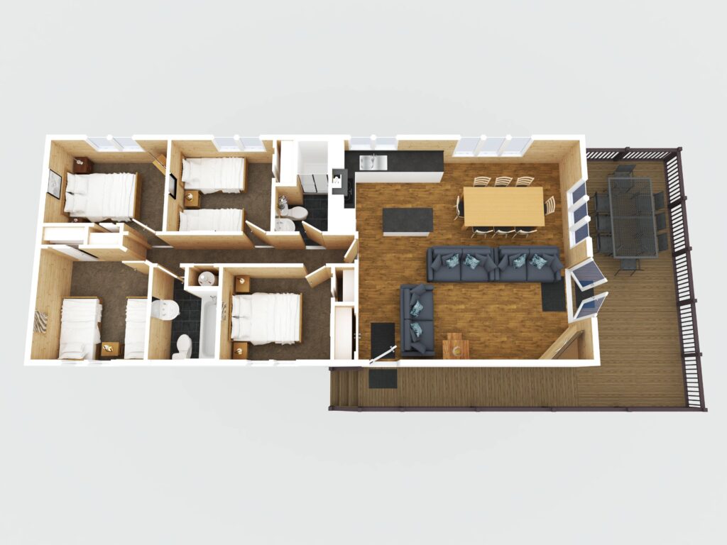
3D floor plans
A 3D floor plan is a digital representation of a property’s layout that shows rooms, furniture, and design elements in three dimensions rather than as a flat, two-dimensional drawing. It gives a realistic sense of space, proportions, and flow, allowing viewers to understand how rooms connect and how the property feels overall. Unlike traditional floor plans, which can be hard to interpret, a 3D version is visually engaging and easy for anyone to understand.
For holiday lets, this is particularly useful because potential guests can quickly see the size and arrangement of rooms, where amenities are located, and how the space suits their needs. It helps set accurate expectations, reducing misunderstandings and complaints. A 3D floor plan also makes a listing look more professional and appealing, which can increase bookings and justify higher rates. It is especially effective for properties with unique layouts or features that photos alone cannot fully convey.
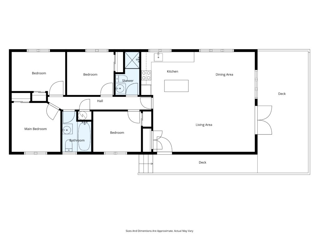
2D schematic floor plans with or without dimensions
A 2D schematic floor plan is a simple, flat drawing that shows the layout of a property from a top-down perspective. It illustrates the arrangement of rooms, walls, doors, and sometimes basic furniture placement, but without depth or perspective. This type of plan is easy to read and provides a clear understanding of how the space is organized.
For holiday lets, a 2D schematic floor plan is useful because it helps potential guests quickly see the size and flow of the property. It sets accurate expectations about room dimensions and layout, which reduces confusion and improves satisfaction. It also makes listings look more professional and trustworthy, which can increase bookings. Guests often appreciate knowing how bedrooms and bathrooms are positioned, especially for group stays or families, and a floor plan provides that clarity better than photos alone.
Provided in the following formats:
- JPG
- PNG
- SVG
Click the image on the right to view a larger version of it
Video walkthrough
A digitally rendered 3D walkthrough in MP4 format is a pre-recorded video that simulates moving through a property in three dimensions. Unlike an interactive virtual tour, which allows the viewer to control navigation, this format is a guided experience that shows the property’s layout, design, and features in a smooth, cinematic way. It is created using 3D modeling or high-resolution scans and then rendered into a video file that can be easily shared on websites, social media, or booking platforms.
For holiday lets, this is highly effective because it gives potential guests a realistic sense of the space without requiring any special software or interaction. It conveys the atmosphere and flow of the property better than static photos, helping guests imagine themselves staying there. This builds trust, reduces uncertainty, and increases booking confidence. It also makes listings look more professional and engaging, which can attract more attention and justify higher rates. Since MP4 videos are universally supported, they are easy to upload and share across multiple platforms, making them a practical marketing tool.
CAD model for residential properties
A CAD model of a property is a detailed digital representation created using Computer-Aided Design software. It shows the structure, dimensions, and layout of the building in a precise and scalable format, often including architectural details, structural elements, and sometimes interior features. CAD models can be two-dimensional for plans and elevations or three-dimensional for a full spatial view of the property.
For holiday lets, a CAD model is useful because it provides an accurate and professional way to showcase the property’s design and layout, which can help with marketing and setting clear expectations for guests. For architects, builders, and engineers, CAD models are essential because they allow for precise planning, design modifications, and collaboration across different stages of construction or renovation. They make it easier to visualize the project, detect potential issues before building, and ensure compliance with regulations. CAD models also integrate well with other technologies such as 3D rendering and virtual walkthroughs, making them a versatile tool for both marketing and technical purposes.
Swipe or use your mouse & click to interact with the following CAD model
Interactive 3D Property Models for Architects and Design Professionals
We produce files including 2D CAD file in .dwg, 3D CAD file in .dwg, Collada file in .dae, .fbx file, .obj filea which are compatible with software such as AutoCad, Revit, Archicad, SketchUp and 3Ds Max
Large-scale 3D models of residential properties provided in .obj, .gltf, and .usdz formats for integration into CAD, BIM, and AR/VR workflows
We create highly accurate interactive 3D models of properties using aerial photography. These models allow architects and property professionals to explore every detail online and download them in industry-standard formats such as .obj, .gltf, and .usdz for seamless integration into CAD, BIM, and AR/VR workflows. This service provides a precise, scalable representation of the building and its surroundings, reducing the need for site visits, improving design accuracy, and enhancing client presentations. It’s an efficient way to visualize, plan, and communicate projects with confidence.
Gross Living Area (GLA) Measurements Document
GLA refers to the total finished, above-grade residential space measured in square feet. It includes areas that are:
- Heated and finished for year-round use.
- Above ground level (basements typically excluded unless they meet specific criteria).
The GLA measurements document is often prepared by appraisers or inspectors to:
- Provide accurate square footage for valuation.
- Ensure compliance with appraisal standards (e.g., ANSI guidelines in the U.S.).
The GLA includes:
- Contents:
- Detailed measurements of each floor.
- Floor plan sketches.
- Notes on excluded areas (garages, unfinished basements, porches).
- Why It Matters: Lenders and buyers rely on GLA for pricing, comparisons, and appraisal accuracy.
Home Report
A home report is a comprehensive document about a property’s condition and value. It’s commonly used in places like Scotland (mandatory for selling a home) and similar concepts exist elsewhere.
- Contents:
- Single Survey: Professional assessment of the property’s condition and valuation.
- Energy Report: Energy efficiency rating and recommendations.
- Property Questionnaire: Seller-provided details (e.g., council tax band, alterations).
- Purpose:
- Gives buyers transparency before making an offer.
- Helps sellers comply with legal requirements.
- Often used for marketing and mortgage purposes.
Snapshot reports
A snapshot report for home appraisers is typically a concise, high-level summary of a property’s key details and market position. It’s designed to give a quick “snapshot” of the home’s value and relevant data without the depth of a full appraisal. These reports are often used by real estate agents, lenders, or homeowners for preliminary insights.
Here’s what a snapshot report usually includes:
- Property Information: Address, square footage, lot size, number of bedrooms/bathrooms, year built.
- Estimated Market Value: A quick valuation based on comparable sales (often automated using AVMs—Automated Valuation Models).
- Comparable Properties (Comps): A short list of similar homes recently sold in the area.
- Market Trends: Local price trends, average days on market, and neighborhood statistics.
- Photos: Sometimes basic exterior/interior images.
- Condition Notes: Brief observations if available (though not as detailed as a full appraisal).
—
For more information on any of the services above, get in touch with us on 0114 383 0711